Last updated:
‘Putting Colonial Victoria on the Map: The 1862 Land Act and its “big map”’, Provenance: The Journal of Public Record Office Victoria, issue no. 6, 2007. ISSN 1832-2522. Copyright © Cate Elkner.
The University of Melbourne’s Cultural Heritage Unit has recently completed a project in partnership with Public Record Office Victoria to digitise a unique record from PROV’s collection — a 4.5 by 6 metre map of Victoria, created by the Parliament of Victoria in 1862.
Digitisation of this map (serialised in VPRS 7664/P3 Unregistered maps and plans, Unit 1) opens up the possibility of making this resource readily accessible to the public for the first time. The next phase of this project will involve exploring the different ways in which this digital resource can be made accessible to researchers on the internet. Technology is available to use the ‘big map’ as the basis for an innovative interactive map which could provide new representations and understandings of land settlement in Victoria.
In this article, map-making, surveying and naming are discussed as crucial activities in the process of the colonisation of Victoria — activities that provide us with insights into the cultural and political perspectives of early European occupiers of the land. The big map from 1862 and its representation of ‘Victoria’ is but one representation of the land, created by the colonial government.
New technology (such as the TimeMap software developed by the University of Sydney’s Archaeological Computing Laboratory) has the potential to create representations of maps and landscapes that can demonstrate that a map is not a natural reflection of a self-evident reality, but a human construction, and one that is open to contestation from those who might see the landscape in different ways.
Records in Public Record Office Victoria’s collection take many forms beyond the typical paper document. This article discusses a recent project involving one of the largest items in the collection, a 4.5 by 6 metre map of Victoria created by the Parliament in 1862.[1] This map came into being as a requirement of the Land Act 1862 (commonly known as the Duffy Act after its sponsor, Charles Gavan Duffy, who was in charge of the Lands Department in 1858-59 and 1861-63). The large map was lodged with the Clerk of Parliaments both as a requirement of the Duffy Act and to enable the public display of this depiction of the 10 million acres of land made available for selection by the Act.
This map, which comprises a series of smaller lithographs pasted onto a seamless backing, was originally hung on the wall in Parliament, on rollers (a bit like a household holland blind). It presumably remained on display in Parliament House until 1865, the year of the next Land Act. Some time after the map was taken down, it was placed in a specially constructed wooden box and stored in the basement of Parliament House, until its transfer to PROV.[2]
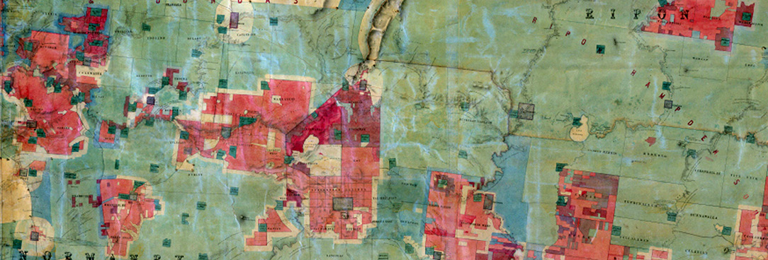
This storage of the map in the wooden box and minimal handling since it was consigned to the basement have resulted in a very well-conserved record for PROV’s collection. In addition to its significance as an object, or even an icon, this map as a record provides a succinct visual representation of the alienation of land in the colony of Victoria, from the first land sales overseen by La Trobe in 1837, up to the Duffy Act in 1862. The boundaries of the system imposed on the landscape by successive lands administrators, categorising areas of the land as parishes and counties, are clear, as are the towns then in existence, as well as natural features of Victoria’s topography and landscape. As Farrugia and Nelson have stated, the 1862 Land Act map depicts ‘the extent and limits of settlement in the colony of Victoria to that time’.[3] A major issue with this record for PROV was how to provide access to the map and to the evidence it provides of the administration of public land in the colony.
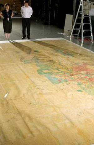
PROV, VPRS 7664/P3 Unregistered Maps and Plans (Legislative Assembly), Unit 1.
The internet was an obvious solution to this issue of providing access to the 1862 map. There were also clear preservation and conservation advantages associated with the digital capture of this record. With assistance from a seeding grant from the Faculty of Arts at the University of Melbourne, the Cultural Heritage Unit in partnership with PROV arranged for the digitisation of the map in December 2006. A company called Photography Department was engaged to photograph the map, a process which took three days and involved photographers, PROV’s repository staff and conservators.
The method used was to roll out the map to its full size on the floor of the studio, then, using a special scaffold, photograph the map from above. Due to its size, the map had to be photographed in segments, and then these segments of the map were digitally ‘stitched’ together to provide us with a complete image of the 1862 map. Now that this work has been completed, it is possible to progress to the next phase of the project, which is to make this digitised map available on the internet. Access to the digitised map will make possible new research enquiries into land settlement in Victoria and should lead to new insights about this aspect of Victoria’s history.
The big map can be conceived as a visual representation of Victoria, providing evidence about the history of the alienation of crown land in Victoria up to 1862. But this record also offers some insights into how the landscape in Victoria was imagined and represented by colonial governments.
This map’s particular representation of Victoria shows a vexed situation that had been the subject of political agitation and debate from the colony’s earliest days — namely, the occupation of large land-holdings by ‘squatters’. This situation became a bitter struggle between the interests of squatters and those in favour of smaller-scale agriculture, particularly from the 1850s, when calls to ‘unlock the lands’ first began to be heard.
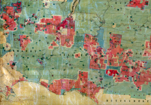
The big map contains various blue-coloured areas, indicating the 10 million acres of land to be made available to selectors by the Duffy Act. Four million acres were offered for immediate selection with the passing of the Act in September 1862. The map can be seen as the government’s offering to the vocal advocates of land reform in Victoria, many of whom were now members of the Lower House. John Ireland sees the 1862 Act as Duffy’s attempt at a compromise between the reformers who were calling for the land to be opened up to the ‘poor man’, and the squatters whose interests were protected by many in the Upper House.[4] For the Duffy Act not only purported to offer new lands for selection, but also to give some security of tenure to squatters who could obtain yearly occupation licences under the new system.
As it happened, the situation was far more complex than the neat depiction offered by the big map. Far from offering a political solution to the tensions between selectors and squatters, the Duffy Act (like other land acts which preceded it) contributed to yet more struggles and controversy in Victoria. Within days of the legislation being passed on 10 September 1862, it was clear that once again, large holdings of land were being acquired for sheep grazing rather than small-scale agriculture. The system was wide open for abuse by squatters, who used ‘dummies’ or middlemen to snap up the prime portions of land available for selection. Some genuine selectors also sold their holdings straight back to squatters, motivated by the prospect of a much quicker profit than that offered by a life on the land.
Victoria’s newspapers were scathing in their assessment of Duffy and his Act. A week after its passage the Geelong Advertiser posed the question, ‘Is Mr Duffy a rogue? Is he a fool? Or is he a compound of both?’.[5] A letter to Duffy was published in the Age on 18 September, from ‘The Squatter’ of Hamilton, who wrote, ‘My dear Duffy, The Land Act has worked admirably. It is true that the oi polloi have secured some small hopes and farms … but we have mopped up some hundred and fifty thousand acres of the finest land in Victoria.’[6]
Roberts contends that, of the four million acres made available for selection when the Duffy Act was passed in September 1862, some two million fell into the hands of a small group of squatters.[7] The common conclusion about the Duffy Act is that it was a dismal failure, and achieved the exact opposite of its stated aims, leaving the squatters with an even greater proportion of Victoria’s land. This had the effect of stopping agricultural expansion into the western district, and directing selectors onto poorer lands in the wimmera and Gippsland, necessitating the development of expensive infrastructure such as railways and irrigation to support these farming enterprises.[8]
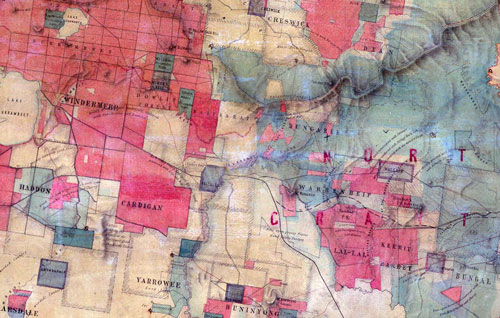
Of course, the big map does not indicate these outcomes of the 1862 Land Act. It is an historical snapshot of land alienation in Victoria before the passage of the Duffy Act, as well as a representation of the government’s grand plans for the future. Healy has written about maps in colonial Australia and their dual representation of past and future, contending that maps were used by governments to invent the future of the colony, filling in the ‘blanks’ with promises of new farms, buildings, towns, railways and roads.[9] The future promised by the big map never eventuated. Indeed, the version of the past that it encapsulates is also open to contestation.
Landscapes are never natural: they are human, cultural constructions that change over time. In the words of John B Jackson, ‘landscape is the place where we establish our own human organization of space and time’.[10] Nineteenth-century Victoria as a landscape was constructed differently by different communities — the Indigenous population, the explorers, the squatters, and colonial governments. The activities of the earliest colonial map-makers in Victoria, such as Major Thomas Mitchell, explorer and Surveyor-General, were not representing ’empty’ space, but overlaying their own understanding on an existing landscape which had been constructed over thousands of years by the Kulin nations. Indeed, Mitchell’s travels into Victoria in 1836, and his map-making and naming activities, were a crucial element of the colonisation and settlement of Victoria. The big map at PROV can be seen as the administrators’ representation of the success of the colonising project in Victoria and the imposition of order, civilisation and progress onto what was seen as empty wilderness.
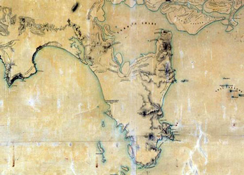
The big map is a record like any other; it can also be seen as an object, and even as a treasure of PROV’s collection. As a result of the digitisation project, we are interested in interpreting the big map as more than a self-evident representation of ‘Victoria’. Technology now offers the potential for the map to be made accessible on the internet in a way that will make evident the complexity and contestation of the history of land settlement in Victoria.
We hope to embark in the coming year on the next phase of this project, exploring the use of software to develop an online interactive map, where earlier, later and alternative maps of Victoria can be overlaid onto the 1862 record, so that a range of interpretations of the landscape are made possible. Ultimately, we hope to use the big map as the basis for developing an interactive map of Victoria that is a gateway to a range of historical maps and other sources, and a valuable resource for academics, students and the general public. From this resource, new stories about land, landscape and land settlement might be able to be told.
We are currently exploring the suitability of the TimeMap software for such a project. TimeMap, developed by the University of Sydney’s Archaeological Computing Laboratory, makes possible the online delivery of interactive maps that can represent information about both space and time. For example, new understandings of the past would be made possible by overlaying on the 1862 map information about traditional Aboriginal ownership clans and language groups in Victoria. Maps of Victoria that came into being after 1862 could also be overlaid onto the big map. TimeMap also provides a way to easily link online interactive maps with other digitised resources, so that the big map could provide an alternative entry point to PROV’s lands records.
TimeMap would further allow us to feed historical information from multiple voices and sources (such as oral histories, artworks, and digitised records) into the interactive map, so that these stories could be represented alongside the depiction of Victoria contained in the big map. Visitors to the online interactive map would be able to contribute their own information to the resource, establishing links between particular sites on the big map and their own artefacts, such as personal accounts of a place, event or person, or photographs. This functionality would make possible multiple interpretations of the big map and its particular narrative of the development and settlement of Victoria.
The development of such an online resource is currently in the project scoping phase. In the near future we hope to make the digitised version of the 1862 map available to researchers on the internet. Researchers will be able to zoom in to see the intricate detail of this remarkable record. Hopefully, new understandings of our past will result from PROV’s researchers seeing the big map for the first time. It is a fascinating record that has been inaccessible for too long.
Endnotes
[1] Map of the Colony of Victoria comprising ten million acres and upwards delineated in blue tint and initialled by the President of the Board of Land and Works, in pursuance of the provisions of [Section 12 of] the Land Act of 1862, PROV, VPRS 7664/P3 Unregistered Maps and Plans (Legislative Assembly), Unit 1.
[2] For a detailed discussion of the 1862 map, see C Farrugia and P Nelson, ‘The 1862 Land Act map’, The Globe: Journal of the Australian Map Circle Inc., no. 57, 2005, pp. 35-7.
[3] ibid., p. 36.
[4] John Ireland, The Victorian Land Act of 1862 revisited, MA thesis, University of Melbourne, 1992, p. 26.
[5] Geelong Advertiser, 17 September 1862.
[6] Age, 18 September 1862.
[7] SH Roberts, History of Australian land settlement 1788-1920, Macmillan, Melbourne, 1968, p. 252.
[8] ibid., p. 252.
[9] C Healy, From the ruins of colonialism: history as social memory, Cambridge University Press, Melbourne, 1997, p. 111.
[10] JB Jackson, Discovering the vernacular landscape, Yale University Press, New Haven, 1984, p. 156.
Material in the Public Record Office Victoria archival collection contains words and descriptions that reflect attitudes and government policies at different times which may be insensitive and upsetting
Aboriginal and Torres Strait Islander Peoples should be aware the collection and website may contain images, voices and names of deceased persons.
PROV provides advice to researchers wishing to access, publish or re-use records about Aboriginal Peoples
